


Blog
Kollectr: Offline-First iOS
Transport Survey App
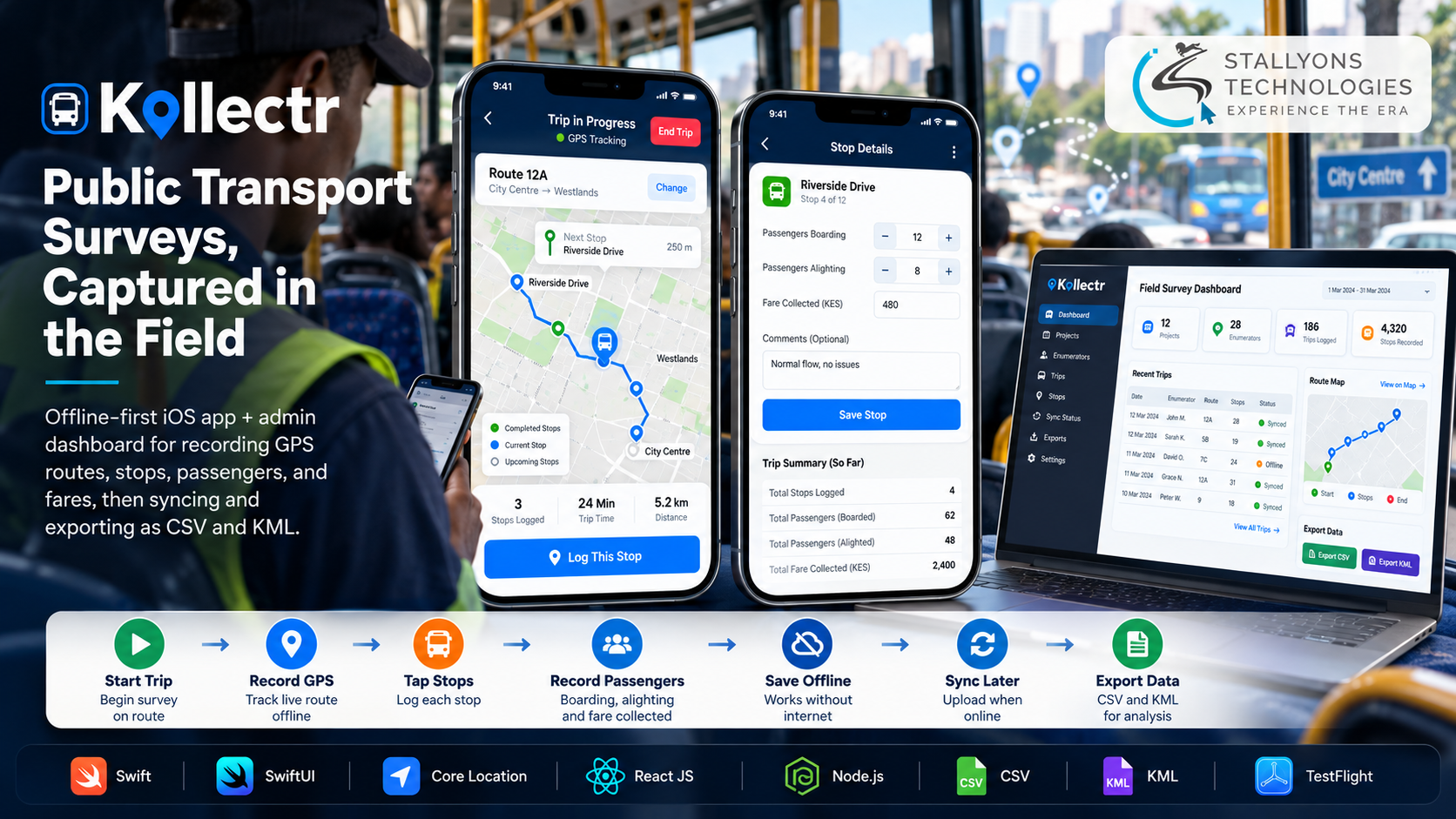
A survey worker rides a minibus along a route that drops out of mobile coverage for twenty minutes at a stretch. People are getting on and off, fares are changing hands, and the vehicle keeps moving. A tool that needs the internet to save a record would lose the very data the trip exists to capture, exactly where the signal is weakest.
Kollectr was built so that never happens. It is a field data collection platform for public transport surveys, built for Transdata Consult, a transport data consultancy. Survey workers, called enumerators, ride buses and minibuses with the app. They record the vehicle’s route by GPS, mark every stop, and log how many passengers board and alight and what fares are paid. Back in the office, an admin dashboard shows every trip, lets the team check and clean the data, and exports it as CSV for analysis or KML for route mapping.
Put simply, an enumerator starts a trip and the app records GPS in the background for the whole journey, saving each stop to the phone the moment it is tapped, with no signal required. When the phone is back online, the trips sync to the online database, and admins review, filter, flag, and export them. Everything is saved on the device first, so a full day of fieldwork can be done with no connection at all and nothing is lost.
The Starting Point: Capture in the Field, Lose Nothing
The consultancy already knew the work, but its tools were holding it back. Paper and generic form apps were slow on a moving vehicle and could not record the route itself. The new platform had to be reliable where coverage is poor, built around how a transport survey actually runs, and owned by the business rather than borrowed from a third party. That set the requirements.
- Work with no signal. Many routes pass through dead zones, so every record had to be saved on the phone the instant it was made, then synced later.
- Record the route, not just the stops. Clients want the actual path a vehicle took, which means continuous GPS tracking and a map-ready export.
- Make stop logging fast and accurate. Marking a stop, with boardings, alightings, fare, and a name, had to be a single tap stamped with the exact position and time.
- Give admins real control. The office needed to know which enumerator worked on which project, what had synced, and which entries needed checking, all in one place.
- Be a platform the business owns. The team wanted its own branded system, in its own colours, with room to add survey and interview forms later.
The Build: Start a Trip, Tap Each Stop, Sync and Export
Kollectr turns each trip into a clean, structured record. Because the route recording has to hold up on the road with the screen locked, the client wanted a native iOS app development company rather than a cross-platform shortcut that gives up control of background location. A trip runs in a set order:
- The enumerator logs in with a project code and their enumerator ID, so every trip is tied to the right person and project.
- They pick the project and start a trip, choosing the vehicle type, such as minibus or bus, the operator, and the date, which fills in automatically.
- The app records GPS continuously in the background for the whole journey.
- At the starting stop, each stop along the way, and the final stop, one tap marks it and captures boardings, alightings, the fare, the stop name, and any comments.
- At the end, the enumerator stops recording and reviews a trip summary of stops, passengers, and fares.
- Everything saves on the phone first and syncs to the online database when a connection returns.
On the web, admins log in to add projects and enumerators, see all collected data, and filter by date, enumerator, location, or vehicle type. They open detailed trip logs, edit or flag entries, check sync status per enumerator, and export records as CSV or KML. The dashboard was also designed with placeholders for a future KoboToolbox integration, so the platform can grow into general surveys and interviews without a redesign.
Technical Architecture
Kollectr pairs an offline-first native iOS app with a React dashboard and a central API. Each piece is chosen for reliability in the field, where the hard part is not the forms but keeping every record safe without a connection and syncing it later without duplicates.
- Mobile app. The enumerator app is built in Swift with SwiftUI, for native performance and full access to GPS and on-device storage.
- Offline storage. Core Data on the iPhone saves trips, stops, and GPS points instantly, so no signal is ever needed to record.
- Location. Core Location in background mode records the full route even with the screen locked or while the enumerator is typing in stop data.
- Backend. A Node.js REST API handles login, trip upload, sync status, and exports.
- Admin dashboard. A React web panel manages projects, enumerators, and survey data in the browser. The fresh, branded look came from a round of UI/UX design in the consultancy’s own colours rather than a copy of the old tool.
- Exports and distribution. CSV and KML generation produce data for analysis and routes for mapping tools, and TestFlight handles field testing before any App Store release.
The part worth engineering carefully was sync. Every trip, stop, and GPS point carries a unique ID created on the phone, so a half-finished upload that gets retried on a weak network can be accepted twice without ever creating a duplicate. Admins see exactly what has and has not arrived for each enumerator, which is what makes “zero data lost” a claim the team can actually stand behind.
Challenges Solved
The hardest problems were the ones that quietly ruin field data. GPS gaps were solved with Core Location’s background mode, so the route keeps recording while the phone is locked and the blue location indicator shows tracking is live. Duplicate records on flaky networks were solved by stamping every record with a unique ID, so a retried upload is safe. The need for a distinct, owned product was solved by reworking the designs with the client, in a new layout and colour scheme, with placeholders for future survey and KoboToolbox features.
Reviewing a build in stages was its own challenge, because a front end without a back end is hard for a client to judge. The team shared clickable builds at each stage, then agreed a written backend specification before connecting anything, so login, sync, and exports were understood before they were built. That discipline around field reliability and clean hand-off is what logistics and transport operators need from data they plan to act on.
The Result
The outcome is a working platform delivered end to end: an offline-first iOS app, a React admin dashboard, and a demo video of the full flow in October 2025. It runs two roles, enumerator and admin, captures full trips with no signal, and exports every project as both CSV for analysis and KML for mapping. As agreed with the client, the app is shared through TestFlight for field testing before any public App Store release.
The build works because it was designed around how a transport survey really happens, a trip with a route and a sequence of stops, rather than a generic form. If you are planning a field tool that has to work offline and sync cleanly, you can hire dedicated developers who have shipped this exact pattern, or tell us about your fieldwork and we will map it to an app and dashboard that lose nothing.
Frequently Asked Questions
What does “offline-first” mean in the Kollectr app?
It means every trip, stop, and GPS point is saved to a database on the phone the moment it is recorded, using Core Data. The app never waits for a connection. A whole day of fieldwork can be done with no signal, and the records sync to the server once the phone is back online.
How does Kollectr record a vehicle’s full route?
The iOS app uses Core Location in background mode, with the user’s permission, so GPS keeps recording the route even while the phone is locked or the enumerator is entering stop data. Each stop is stamped with its exact position and time, and the route exports as KML for mapping tools.
How does syncing avoid duplicate records on weak networks?
Every trip, stop, and GPS point carries a unique ID created on the phone. If an upload fails halfway and is retried, the server can safely accept the same record twice without creating a duplicate. Admins can see exactly what has synced for each enumerator.
What can admins do from the dashboard?
Admins add projects and enumerators, see all collected data, and filter by date, enumerator, location, or vehicle type. They open detailed trip logs, edit or flag entries, monitor sync status, and export records as CSV for analysis or KML for route mapping.
Can the same platform handle other kinds of surveys later?
Yes. The dashboard was designed with placeholders for a future KoboToolbox integration and for general survey and interview forms, so the consultancy can add new survey types later without redesigning the system.